Observatories

CRYOBS-CLIM

CRYOBS-CLIM ((The CRYosphère, a CLIMATE Observatory), is labeled in 2015 and is structured around the monitoring of the major components of the cryosphere: mountain glaciers / polar ice caps, snow cover and mountain permafrost. CRYOBS-CLIM is a SOERE grouping together 8 French laboratories and foreign partners, representing 53 actors in total. This new SOERE brings […]

Observatories

AMMA-CATCH

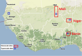
AMMA-CATCH is a hydrological and meteorological observatory on West Africa. This national observation service (SNO) is dedicated to long-term monitoring of climatological, hydrological and ecological changes in West Africa. For this purpose, it gathers data from three mesoscale sites, which cover areas ranging between 10000 and 25000 km². The three sites are located at different […]

Events

Building OZCAR’s community!

OZCAR is a scientific community designed around an instrumental park and long-term observation sites to explore the Critical Zone.

Observatories

AgrHys

AgrHyS (response times in AgroHydroSystems), certified as Environment Research Observatory in 2002, is managed by INRA Rennes in collaboration with CNRS and Rennes Universities. It comprises two sites: Kervidy-Naizin in Morbihan, monitored by Cemagref since the establishment of Naizin BVRE (Bassin versant représentatif et expérimental) in 1970, in the Coët Dan watershed defined by the […]

Data

Theia land data services centre

The Theia land data services centre is a French national inter-agency organization designed to foster the use of images issued from the space observation of land surfaces. Theia is offering scientific communities and public policy actors a broad range of images at different scales, methods and services. https://www.theia-land.fr/en/presentation/products

Données

Pôle de données et de services surfaces continentales Theia

Le pôle de données et de services surfaces continentales Theia a pour vocation de faciliter l’usage des images issues de l’observation des surfaces continentales depuis l’espace. Theia met à disposition de la communauté scientifique et des politiques publiques une vaste panoplie d’images à différentes échelles, des méthodes et des services. Theia apporte de la valeur […]

Données

Catalogue de données du Réseau des bassins versants

Un portail de métadonnées a été développé. Ce portail est construit à l’aide de GeoNetwork, système de gestion des métadonnées géographiques, gratuit, open-source et implémentant une large majorité des normes et des échanges de données. Le portail utilise également GeoNetwork, overlay GeoNetwork fournissant des spécificités liées à la gestion européenne INSPIRE. Les métadonnées du portail […]

Data

Metadata catalog watershed network

A metadata portal Watershed Network was developed. This portal is built using GeoNetwork, geo metadata management system, free, open-source and implementing a large majority of data standards and exchange. The portal also uses GeoNetwork, overlay GeoNetwork providing specifics related to the European INSPIRE management. The portal metadata allows network members to enter / edit the […]